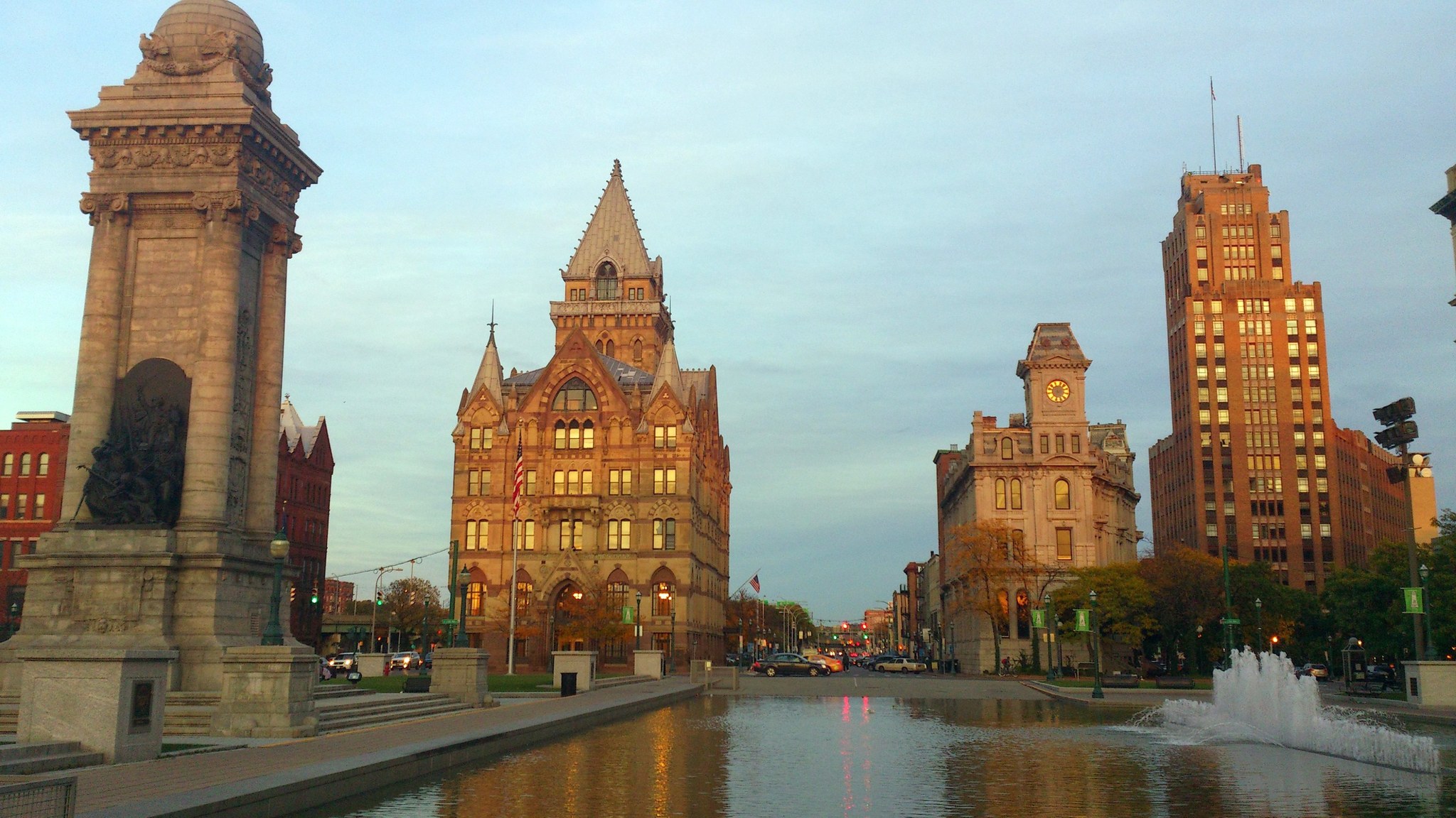
Clinton Square in downtown Syracuse, New York, in evening light.

Outdoors

Hiking near Syracuse

National forests, parks, lakes and recreation areas with hiking trails near Syracuse, closest first.

16places to hike
31 mito the closest
April–Novemberbest months

Good to know: Carry more water than you think you need, check the managing agency’s page for trail closures and fire restrictions, and start early on hot days.

Closest picks

1

Montezuma National Wildlife Refuge

31 mi west · Fish and Wildlife Service

Establishing the Montezuma National Wildlife Refuge in 1938 was the first step of many to restore the area back to its historic expanse of marshes—an area thriving with wildlife, once used by indigenous people for hunting and fishing.
2

Fort Stanwix National Monument

37 mi east · National Park Service

For centuries, the Oneida Carrying Place, a six-mile portage connecting the Mohawk River and Wood Creek, served as a vital link for those traveling by water from the ocean to the Great Lakes.

3

Whitney Point

39 mi south · US Army Corps of Engineers

Broome County operates Dorchester Park on Whitney Point Lake. Day use facilities include a beach, boat launch, picnic area, pavilions and open play areas.

Map of all 16 places

Map of 16 places loads as you scroll.

30 to 75 miles (5)

31 mi west · Fish and Wildlife Service

Montezuma National Wildlife Refuge

Establishing the Montezuma National Wildlife Refuge in 1938 was the first step of many to restore the area back to its historic expanse of marshes—an area thriving with wildlife, once used by indigenous people for hunting and fishing.

  • Birding
  • Boating
  • Cross Country Skiing
  • Educational Programs
  • Fishing
  • Hiking
  • Hunting
  • Motor Boat

37 mi east · National Park Service

Fort Stanwix National Monument

For centuries, the Oneida Carrying Place, a six-mile portage connecting the Mohawk River and Wood Creek, served as a vital link for those traveling by water from the ocean to the Great Lakes.

  • Biking
  • Hiking
  • History
  • Picnicking

39 mi south · US Army Corps of Engineers

Whitney Point

Broome County operates Dorchester Park on Whitney Point Lake. Day use facilities include a beach, boat launch, picnic area, pavilions and open play areas.

  • Biking
  • Boating
  • Hiking
  • Picnicking
  • Water sports
  • Wildlife viewing
  • Winter sports

49 mi southwest · USDA Forest Service

Green Mountain & Finger Lakes National Forests

  • Biking
  • Fishing
  • Hiking
  • Horseback riding
  • Picnicking
  • Swimming
  • Wildlife viewing
  • Winter sports

50 mi southwest · USDA Forest Service · Campground

Potomac Group Campground

Potomac Group Campground and Day Use Area provides a primitive camping experience for groups of 8-40 people. It is an excellent site for family events and youth group activities.

  • Camping
  • Fishing
  • Hiking
  • Hunting
  • Swimming
  • Wildlife viewing
  • Winter sports

75 miles and farther (11)

90 mi southwest · US Army Corps of Engineers

Cowanesque Lake

This Corps project located near the New York state line in North Central Pennsylvania provides a 1,085-acre lake with 17 miles of shoreline for use by campers and day trippers.

  • Boating
  • Camping
  • Fishing
  • Hiking
  • Nature education
  • Picnicking
  • Water sports
  • Wildlife viewing

91 mi southwest · US Army Corps of Engineers · Campground

Lawrence Recreation Area

Lawrence Recreation Area is a day-use facility on the south side of Cowanesque Lake. It is conveniently located on State Route 49 approximately 4 miles west of Lawrenceville, Pennsylvania.

  • Camping
  • Fishing
  • Hiking

91 mi southwest · US Army Corps of Engineers · Campground

Tompkins

Tompkins Campground is on the north shore of Cowanesque Lake in the northern tier of Pennsylvania, less than one mile from the New York state border.

  • Boating
  • Camping
  • Fishing
  • Hiking

92 mi west · US Army Corps of Engineers

Mount Morris Dam and Recreation Area

The US Army Corps of Engineers built the Mount Morris Dam in the late 1940s to reduce flooding on the lower Genesee River.

  • Boating
  • Hiking
  • Picnicking
  • Water sports
  • Winter sports

92 mi southwest · US Army Corps of Engineers · Campground

South Shore Recreation Area

South Shore Recreation Area is located on the south side of the Cowanesque Lake along State Route 49, just five miles west of Lawrenceville, Pennsylvania.

  • Boating
  • Camping
  • Fishing
  • Hiking

93 mi southwest · US Army Corps of Engineers

Almond Lake

Kanakadea Park operated by Stuben County, NY is located on Almond Lake. Camping and day use facilities for picnicing and boating are available.

  • Boating
  • Camping
  • Hiking
  • Hotel/Lodge/Resort Privately Owned
  • Picnicking
  • Water sports
  • Wildlife viewing

94 mi southwest · US Army Corps of Engineers

Tioga-Hammond Lakes

Twin lakes in north central Pennsylvania with overnight and dayuse facilities in a scenic environment, southwest of Tioga, PA and north of Wellsboro on PA Route 287, which is acessable from U.S. Route 15 northeast of Tioga and U.S.

  • Boating
  • Camping
  • Fishing
  • Hiking
  • Nature education
  • Picnicking
  • Water sports
  • Wildlife viewing

96 mi southwest · US Army Corps of Engineers · Campground

Ives Run

Ives Run Campground sits on the eastern shore of Hammond Lake in north-central Pennsylvania.

  • Boating
  • Camping
  • Disc Golf
  • Fishing
  • Hiking
  • Hunting
  • Swimming

97 mi southwest · US Army Corps of Engineers · Campground

Lambs Creek Recreation Area

Lambs Creek Recreation Area is located at the southern end of Tioga Lake, just north of the borough of Mansfield, PA. The recreation area is easily accessible from US Route 15 and offers a great location for picnicking, hiking and biking.

  • Biking
  • Camping
  • Hiking
  • Hunting

114 mi west · Fish and Wildlife Service

Iroquois National Wildlife Refuge

Our namesake comes from the Iroquois (Haudenosaunee) Confederacy, a powerful and enduring alliance that has thrived in the northeast for centuries.

  • Biking
  • Birding
  • Boating
  • Cross Country Skiing
  • Fishing
  • Hiking
  • Hunting
  • Ice Fishing

127 mi east · National Park Service

Saratoga National Historical Park

In 1777, a large British invasion force met an equally large American army here at Saratoga. After two intense battles, an eight-mile retreat, and a three-day siege, British General John Burgoyne surrendered his entire force.

  • Biking
  • Hiking
  • History
  • Horseback riding
  • Picnicking
  • Snowpark
  • Wildlife viewing

Distances are straight-line miles from downtown Syracuse. Listings come from Recreation.gov’s federal recreation database; check each official page for hours, fees, fire restrictions and closures before you go.

Get outside around Syracuse

Around Syracuse

Billings Park, Syracuse, New York
Billings Park, Syracuse, New YorkKenneth C. Zirkel · CC BY-SA 4.0
Hall of Languages, Syracuse University (2024)
Hall of Languages, Syracuse University (2024)Kiran891 · CC BY-SA 4.0
First English Lutheran Church, James Street and Townsend Street, Near Northeast, Syracuse, NY
First English Lutheran Church, James Street and Townsend Street, Near Northeast, Syracuse, NY (54415524357)Warren LeMay from Chicago, IL, United States · CC BY-SA 2.0

More outdoors near Syracuse

Questions

Where is the closest place for hiking near Syracuse?

Montezuma National Wildlife Refuge (Fish and Wildlife Service), about 31 miles west of Syracuse as the crow flies. Next are Fort Stanwix National Monument (37 mi) and Whitney Point (39 mi).

When is the best time for hiking near Syracuse?

Based on Syracuse’s average highs, April–November. Conditions at higher elevations can be much cooler.

Who manages these places?

Federal agencies including US Army Corps of Engineers, Fish and Wildlife Service, National Park Service. Each listing links to its official page for hours, fees, closures and current conditions.

Syracuse AI

Your Syracuse local guide
Hey there!

I'm Syracuse AI. Ask about local food, shopping, history or a day out.

AI recommendations may be inaccurate. Verify hours and prices. Questions are processed by Cloudflare. Privacy